
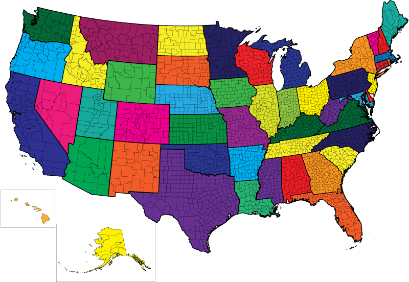
Why are Towns in Massachusetts odd shapes and square in other parts of the country?
The Original 13 Colonies used a system of measurement called metes and boundaries which relies on natural features such as streams to measure boundaries. Congress under the Articles of Confederation passed the Northwest Ordinance that became the model for subsequent land survey of United States territory. This survey system divided townships into an area of six miles square.
Northwest Ordinance
Land measurement systems
-
Metes and Bounds - A surveying system used for the original 13 colonies that describes the perimeter of a parcel of land in terms of its bearings and distances and its relationship to natural features and adjacent parcels.
13 Colonies
- New Hampshire
- Massachusetts - included Maine (statehood 1820)
- Rhode Island
- Connecticut
- New York - included Vermont (statehood 1791)
- New Jersey
- Pennsylvania
- Delaware
- Maryland
- Virginia - included Kentucky (statehood 1792) and West Virginia (statehood 1863)
- North Carolina – included Tennessee (statehood 1796)
- South Carolina
- Georgia
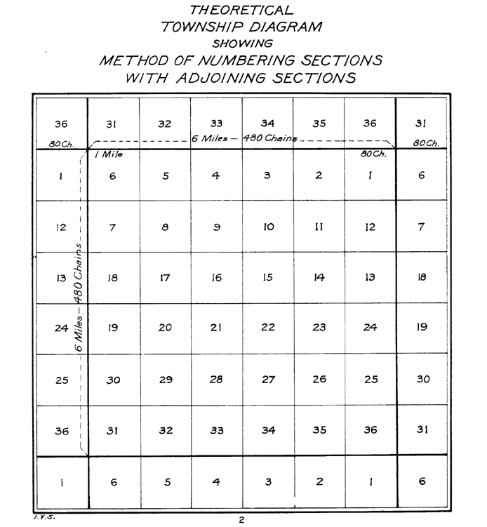
- Public Land Survey System (PLSS) - A surveying system used in the United States to identify public land parcels normally in a rectangular area. A basic unit of this system is a township which contains 36 sections in an area six miles square. The PLSS may also use meandering. For example, the boundary meanders with a stream meaning the survey line follows the twists and turns of the stream.
State Survey Systems
| State | Survey System |
|---|---|
| Alabama | PLSS |
| Alaska | PLSS |
| Arizona | PLSS |
| Arkansas | PLSS |
| California | Spanish Land Grants and PLSS |
| Colorado | PLSS |
| Connecticut | Metes and Bounds |
| Delaware | Metes and Bounds |
| Florida | PLSS |
| Georgia | Metes and Bounds |
| Hawaii | Kingdom of Hawaii system in place when annexed |
| Idaho | PLSS |
| Illinois | PLSS |
| Indiana | PLSS |
| Iowa | PLSS |
| Kansas | PLSS |
| Kentucky | Metes and Bounds |
| Louisiana | French and Spanish Boundaries and PLSS |
| Maine | Metes and Bounds |
| Maryland | Metes and Bounds |
| Massachusetts included Maine (statehood 1820) | Metes and Bounds |
| Michigan | PLSS |
| Minnesota | PLSS |
| Mississippi | PLSS |
| Missouri | PLSS |
| Montana | PLSS |
| Nebraska | PLSS |
| Nevada | PLSS |
| New Hampshire | Metes and Bounds |
| New Jersey | Metes and Bounds |
| New Mexico | Spanish Land Grants and PLSS |
| New York included Vermont (statehood 1791) | Metes and Bounds |
| North Carolina included Tennessee (statehood 1796) | Metes and Bounds |
| North Dakota | PLSS |
| Ohio | PLSS and Metes and Bounds |
| Oklahoma | PLSS |
| Oregon | PLSS |
| Pennsylvania | Metes and Bounds |
| Rhode Island | Metes and Bounds |
| South Carolina | Metes and Bounds |
| South Dakota | PLSS |
| Tennessee | PLSS |
| Texas | Spanish Land Grants and PLSS |
| Utah | PLSS |
| Vermont | Metes and Bounds |
| Virginia included Kentucky (statehood 1792) and West Virginia (statehood 1863) | Metes and Bounds |
| Washington | PLSS |
| West Virginia | Metes and Bounds |
| Wisconsin | PLSS |
| Wyoming | PLSS |